DIGITAL INFRASTRUCTURE · GIS · WATER TECHNOLOGY

Transforming infrastructure
through digital intelligence.

Geospatial, engineering and digital systems that turn field reality into confident infrastructure decisions.

AN END-TO-END CAPABILITY

Infrastructure problems,solved as connected systems.

Horizen connects primary field evidence, spatial databases, engineering models and operational platforms—so each layer strengthens the next.

01

Digital platforms

Enterprise MIS, workflow, verification and decision-support systems for infrastructure programmes.

Web applicationsDashboardsRole-based workflows
Explore full capability
02

Mobile field intelligence

Map-led data capture that keeps field teams productive across low-connectivity environments.

Offline GISGPS & photosValidated sync
Explore full capability
03

GIS & spatial intelligence

District-to-scheme spatial systems for planning, coverage, operations and engineering decisions.

WebGISThematic mappingNetwork intelligence
Explore full capability
04

Survey & engineering

Primary survey, DGPS, drone, CAD and as-built workflows grounded in verified field reality.

DGPS & droneAutoCADAs-built records
Explore full capability
05

Hydraulic intelligence

GIS-integrated EPANET simulation for pressure, flow, storage, controls and network diagnostics.

DDA / PDAEPANETIssue locator
Explore full capability
06

Water quality intelligence

Source inventories, laboratory results, GIS analysis, institutional monitoring and sanitary risk in one management view.

Safe / unsafeSpatial analyticsDecision support
Explore full capability
07

Service verification

Household-level functionality assessment that moves beyond connection counts to service outcomes.

Field verificationReassessmentService status
Explore full capability
08

Monitoring & IoT

Operational dashboards, chlorination visibility, alerts and sensor-linked monitoring concepts.

TelemetryChlorinationOperations
Explore full capability
THE INTEGRATED ECOSYSTEM

One continuous chain of infrastructure intelligence.

Not a menu of isolated services. Each stage carries verified information forward—from primary survey and GIS structuring to hydraulic diagnostics and executive decision support.

Physical evidenceDigital modelDecision support
FIELD EVIDENCE → ENGINEERING DECISIONS
  1. 01

    Own field survey

    Ground-verified assets & alignments

  2. 02

    Network data

    Capture, validate & organise

  3. 03

    GIS / CAD

    Structure the spatial network

  4. 04

    Hydraulic model

    EPANET simulation inputs

  5. 05

    Diagnostics

    Pressure, flow & network review

  6. 06

    Decision support

    WebMIS, reports & action

A connected workflow · Illustrative sequence
Workflow adapted from the Horizen Digital Infrastructure Blueprint
FLAGSHIP CAPABILITY / HYDRAULIC INTELLIGENCE

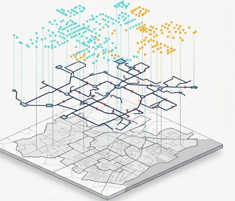
From pipeline map to hydraulic intelligence.

Field-verified network data is structured through GIS and CAD, then transformed into simulation-ready models for engineering analysis and operational decisions.

SurveyGIS / CADEPANETDecision
  • Pressure, flow, velocity and head-loss analysis
  • Pump, valve, tank and supply-window scenarios
  • Automated issue location and engineering warnings
  • Chlorine behaviour and residual evaluation
Explore hydraulic modelling
HYDRAULIC INTELLIGENCE

Model the network.
Understand its behaviour.

  1. Build the model

    Field evidence · GIS / CAD

  2. Simulate scenarios

    EPANET · WaterGEMS

  3. Review performance

    Diagnostics · Engineering decisions

01

Pressure & flow

Understand service conditions

02

Velocity & head loss

Locate network constraints

03

Storage & controls

Compare operational scenarios

04

Chlorine behaviour

Review residual patterns

Engineering workflow illustration · No live simulation results
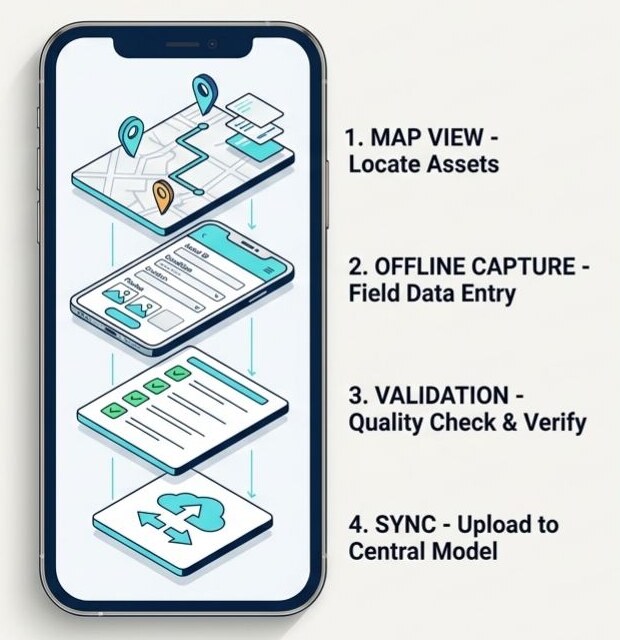
Four-stage mobile GIS workflow showing map view, offline capture, validation and central synchronisation
Survey workflow · Blueprint visual
CENTRAL SYSTEMValidated record received
MOBILE GIS / OFFLINE FIELD APPLICATIONS

Accurate field intelligence. Even when the network is not.

Purpose-built field applications capture map geometry, GPS position, photos and asset information offline—then validate and synchronise records with the central spatial system.

01CaptureMap-led survey, GPS and photo evidence
02ValidateField checks and structured data rules
03SynchroniseControlled offline-to-online transfer
04UseWebGIS, analysis and operational workflows
WATER QUALITY INTELLIGENCE

From source records to water-quality decisions.

Connect source inventories and laboratory results with GIS analysis, institutional monitoring, sanitary risk and management reporting.

  • Source registers & testing coverage
  • Schools, Anganwadi & health centres
  • Sanitary risk & repeat testing
  • Predefined, dynamic & monthly reports
Explore full capability
THE WATER QUALITY JOURNEY
  1. Source identity

    Source registers · Location · Category

  2. Laboratory evidence

    FRC · Arsenic · Iron · Total Coliform · E. coli

  3. Connected analysis

    GIS patterns · Testing coverage · Institutions

  4. Risk review

    Sanitary surveys · Safety status · Repeat testing

  5. Management reports

    Predefined queries · Dynamic queries · Monthly reports

SELECTED WORK / ANONYMISED PROTOTYPE

Evidence-led project stories.

Each public case study is designed to explain the challenge, the connected workflow, the technical output and the resulting decision value.

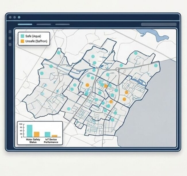
Water-quality monitoring map with safe and unsafe source observations
WATER QUALITY

Integrated quality monitoring & analytics
From sample collection and laboratory results to spatial risk and management reporting.

View capability
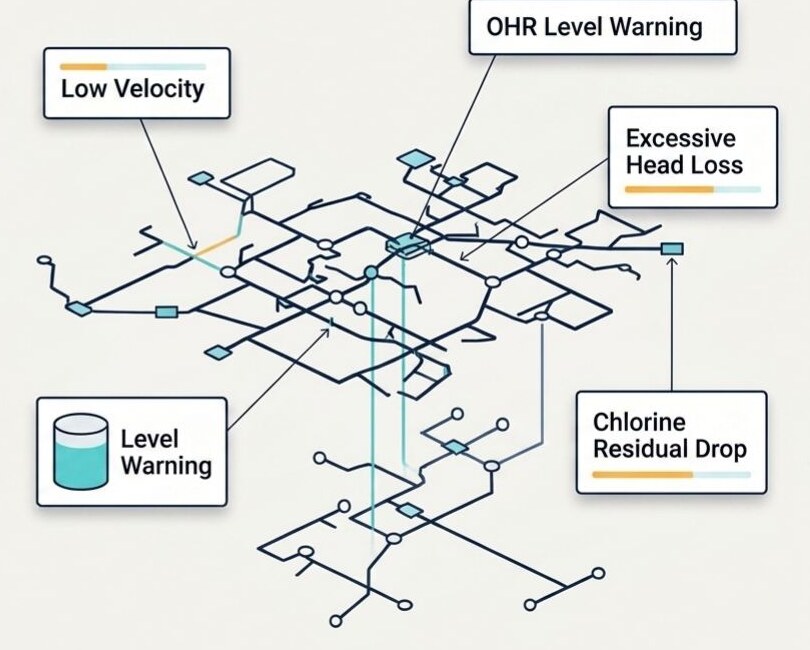
Hydraulic network diagnostics highlighting velocity, head loss, level and chlorine warnings
GIS · EPANET · DIAGNOSTICS

Hydraulic modelling & network diagnostics

Simulation-led visibility of network performance, operational warnings and engineering priorities.

View capability
INNOVATION DIRECTION

Building the next layer of infrastructure intelligence.
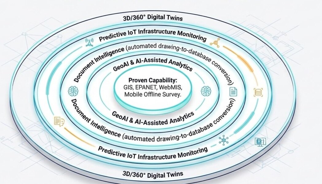
Innovation horizon showing proven capability at the core and GeoAI, document intelligence, predictive IoT and digital twins as future layers
Innovation horizon · Blueprint visual
01

GeoAI

Spatial pattern discovery and assisted analytics

02

Digital twins

Living views of infrastructure and operational state

03

Document intelligence

Accelerated conversion of drawings and records

04

Predictive monitoring

Earlier visibility of emerging operational issues

Clearly presented as innovation and R&D direction—not as deployed production capability.

FROM FIELD REALITY TO DECISION SUPPORT

Let's make infrastructure
intelligence actionable.

Tell us about the infrastructure problem, the data you have and the decisions you need to make.